The Central Meteorological Observatory needs to take corresponding preventive measures when two early warnings are issued simultaneously.
Blue warning of severe convective weather
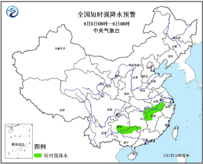
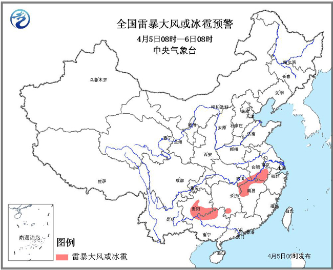
The Central Meteorological Observatory continued to issue a blue warning of severe convective weather at 06: 00 on April 5:
It is estimated that there will be short-term heavy precipitation in some areas of southern Anhui, northwestern Jiangxi, southeastern Hubei, northeastern and southwestern Hunan, southern Guizhou and northwestern Guangxi from 08: 00 on April 5 to 08: 00 on April 6. It is estimated that the hourly rainfall intensity can reach 30-50 mm, and the local area will reach more than 50 mm. There are hail or thunderstorms and strong winds in parts of southern Anhui, southeastern Hubei, northwestern Jiangxi, southern Hunan, south-central Guizhou and northwestern Guangxi.
Defense guide:
1. The government and relevant departments shall, in accordance with their duties, prepare for short-term rainstorm prevention, lightning protection and gale prevention, and the meteorological department shall prepare for artificial hail suppression;
2. Outdoor pedestrians and staff should reduce outdoor activities and pay attention to stay away from structures such as scaffolding billboards;
3. Drive poultry and livestock into places with roofs, and close doors and windows to reinforce sheds;
4. The water operations in relevant waters and passing ships shall take active measures such as returning to Hong Kong to avoid or detour navigation, pay attention to covering building materials at the construction site, and properly arrange outdoor items susceptible to heavy rain, wind and hail;
5. Check the drainage system of cities, farmland and fish ponds, and prepare for drainage and defense against disasters such as mountain torrents, landslides and mudslides.
Typhoon blue warning
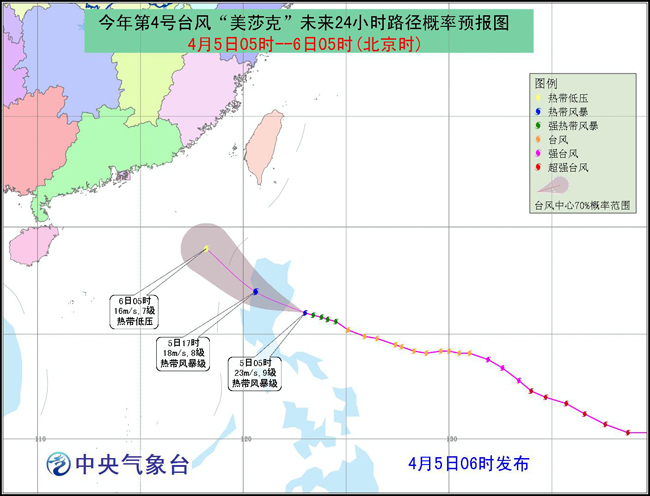
The Central Meteorological Observatory issued a typhoon blue warning at 06: 00 on April 5:
This year’s No.4 typhoon "Mesak" (English name: Maysak;; Name source: Cambodia; Meaning of the name: a tree) was formed in the Pacific Northwest on March 28th, strengthened to super typhoon level on March 31st, and then weakened continuously. Today (5th) at 5 o’clock in the morning, its center is located on the northwest Pacific Ocean about 270 kilometers north-east of Manila, Philippines, which is 16.0 degrees north latitude and 123.0 degrees east longitude. The maximum wind force near the center is 9 (tropical storm level, 23 m/s), the lowest pressure in the center is 988 hectopascals, and the radius of the 7-level wind circle is 50-200 kilometers.
It is estimated that "Mesak" will move to the northwest at a speed of 20-25 kilometers per hour, and its intensity will gradually weaken. It will land in the coastal area of northeastern Luzon Island in the Philippines (8-9, 20-23 m/s), then pass through the northern part of Luzon Island, and will move into the northeastern South China Sea (7-8, 16-20 m/s) around the evening of the 5th.
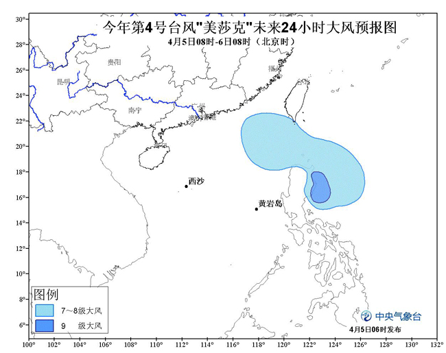
From 08: 00 on the 5th to 08: 00 on the 6th, there will be strong winds of magnitude 7-8 in bashi channel and the northeastern part of the South China Sea, with gusts of magnitude 9 in some sea areas.
Defense guide:
1. The government and relevant departments shall, in accordance with their duties, do a good job in typhoon prevention and emergency rescue;
2. Take active measures for water operations and passing ships in relevant waters, strengthen port facilities, and prevent ships from anchoring, grounding and collision.
(Editor: Su Jessie)